Smaller Wind Farm For Drum Holliston Proposed
21st January 2020
On 21st January 2020 members of the North Planning committee of Highland Council we presented with a Proposal of Application Notice (PAN) for wind farm at Drum Holliston, Caithness. No comments were made by councillors and the applicant will proceed to a full planning application. A previous application for Drum Holliston was refused by Scottish Government in June 2019 - See https://www.dpea.scotland.gov.uk/CaseDetails.aspx?ID=118207
That application was described as -
17 wind turbines (11 with a maximum blade tip height of 119 metres; 4 with a maximum blade tip height of 110 metres; 1 with a maximum blade tip height of 125 metres; and 1 with a maximum blade tip height of 139 metres). Associated infrastructure includes turbine foundations and crane hardstandings; access to the A836; 6.46 kilometres of access track; underground cabling; a substation and control building; and a temporary construction compound including storage and welfare facilities. The predicted installed generating capacity of the wind farm is 51 megawatts.
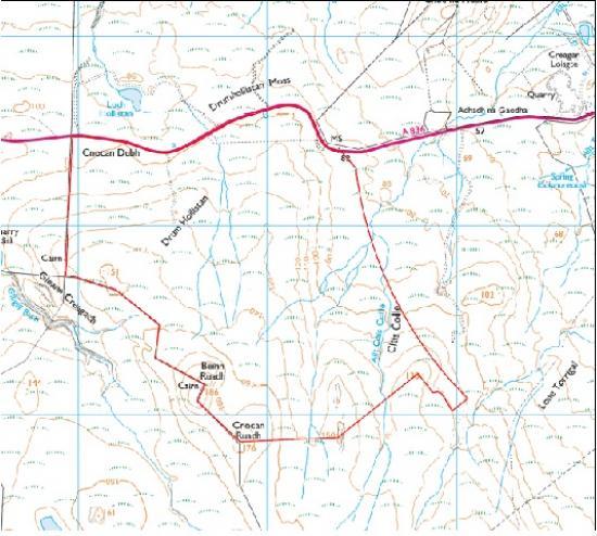
The new application for Drum Holliston is much smaller with 7 turbines.
3. BACKGROUND
3.1 To inform the Planning Applications Committee of the submission of the attached
Proposal of Application Notice (PAN).
3.2 The submission of the PAN accords with the provisions of the Planning etc.
(Scotland) Act 2006 and was lodged and made valid on 11 November 2019.
Members are asked to note this may form the basis of a subsequent planning application
3.3 The submitted information attached includes:
• Proposal of Application Notice
• Location Plan
4. DESCRIPTION OF PROPOSED DEVELOPMENT
4.1 The PAN provides notice of the developer's intention to submit a planning
application for a proposed wind farm (known as Drum Hollistan Wind Farm). The
wind farm would likely comprise of the following infrastructure and has the potential
to generate over 20MW of electricity:
• 7 wind turbines, with a maximum height to blade tip of 125m;
• Access tracks;
• Turbine foundations and transformer plinths and enclosures; and
• Electrical car charging point and recreational walking routes.
5. SITE DESCRIPTION
5.1 The proposed development site forms approximately 224 hectares with the built
development occupying a much smaller area to the south/south eastern boundary
of the site. The application is within the area of a previous scheme refused by
Scottish Ministers following an application under Section 36 of the Electricity Act
1989.
5.2 The site is located approximately 2.1km west of Reay, 3.1km east of Melvich and
4.3km from Portskerra. The immediate area to the south and north of the turbine
envelope is sparsely populated. The site is located adjacent to the A836.
5.3 The site is not located within any natural heritage designation but there are a
number of sites within a 20km radius study area of the site, including the following:
Special Areas of Conservation
• Caithness and Sutherland Peatlands
• Broubster Leans
Special Protection Areas
• Caithness and Sutherland Peatlands
• Caithness Lochs
• North Caithness Cliffs
Sites of Special Scientific Interest
• East Haladale
• Sandside Bay
• Strathy Coast
• Loch Caluim Flows
• Broubster Leans
• Red Point Coast
• Caithness and Sutherland Peatlands
5.4 There are a number of scheduled monuments within a 5km radius of the site.
These include Sandside House, Sandside Harbour and Reay Parish Church.
5.5 There are a number of watercourses present within and adjacent to the site. The
most notable are The Allt Clais Collie, Allt Achnadh na Gaodha and Gleann
Creagach. There is also an unnamed watercourse running through the site and
then out into Drum Hollistan Moss on the north side of the A836.
5.6 The site sits within the Sweeping Moorland and Flows Landscape Character Type.
The Farr bay, Strathy and Portskerra Special Landscape Area lies to the north west
of the site and the East Halladale Flows Wild Land Area is located to the south of
the site.
6. DEVELOPMENT PLAN POLICY
The following policies are relevant to the assessment of the application
6.1 Highland Wide Local Development Plan 2012
28 - Sustainable Design
29 - Design Quality & Place-making
30 - Physical Constraints
31 - Developer Contributions
51 - Trees and Development
52 - Principle of Development in Woodland
55 - Peats and Soils
56 - Travel
57 - Natural, Built & Cultural Heritage
58 - Protected Species
59 - Other Protected Species
60 - Other Important Habitats
61 - Landscape
63 - Water Environment
64 - Flood Risk
66 - Surface Water Drainage
67 - Renewable Energy Developments
68 - Community Renewable Energy Developments
72 - Pollution
77 - Public Access
6.2 Caithness and Sutherland Local Development Plan (2019)
No site specific policies
6.3 Highland Council Supplementary Planning Policy Guidance
Construction Environmental Management Process for Large Scale Projects
(August 2010)
Highland Historic Environment Strategy (Jan 2013)
Highland's Statutorily Protected Species (March 2013)
Highland Renewable Energy Strategy & Planning Guidelines (May 2006)
Onshore Wind Energy: Supplementary Guidance including Landscape Appraisals
(November 2016)
Standards for Archaeological Work (March 2012)
Sustainable Design Guidance
Trees, Woodlands and Development (Jan 2013)
6.4 Scottish Government Planning Policy and Guidance
Scottish Planning Policy (June 2014)
National Planning Framework 3 (June 2014)
Onshore Wind Policy Statement (December 2017)
Scottish Energy Strategy (December 2017)
PAN 1 / 2011 - Planning and Noise;
Circular 1/2017 - Environmental Impact Assessment;
PAN 60 – Planning for Natural Heritage;
2020 Routemap for Renewable Energy;
Onshore Wind Turbines; and
Wind Farm developments on Peat Lands.
7. POTENTIAL MATERIAL PLANNING CONSIDERATIONS
7.1 • Development Plan;
• National Policy;
• Planning History;
• Roads and Transport;
• Water Environment (including private water supplies);
• Flood Risk and Drainage;
• Peat;
• Natural Heritage (including protected species, ornithology and designated
sites);
• Trees and Forestry;
• Built and Cultural Heritage;
• Design, Landscape and Visual Impact (including Cumulative impacts and
Impact on Wild Land Areas);
• Access and Recreation;
• Economic Impact and Tourism;
• Noise and Shadow Flicker;
• Telecommunications;
• Aviation;
• Construction.
8. CONCLUSION
8.1 The report sets out the information submitted to date as part of the PAN.
Summarised are the policy considerations against which any future planning
application will be considered as well as the potential material planning
considerations and key issues based on the information available to date. The list
is not exhaustive and further matters may arise as and when a planning application
is received and in the light of public representations and consultation responses.