
Further Snow And Ice Warnings In The Forecast With A Cold Week To Come
6th January 2025
he UK's cold snap will continue this week, with low pressure remaining in charge bringing below-average temperatures and the potential for disruption in places.
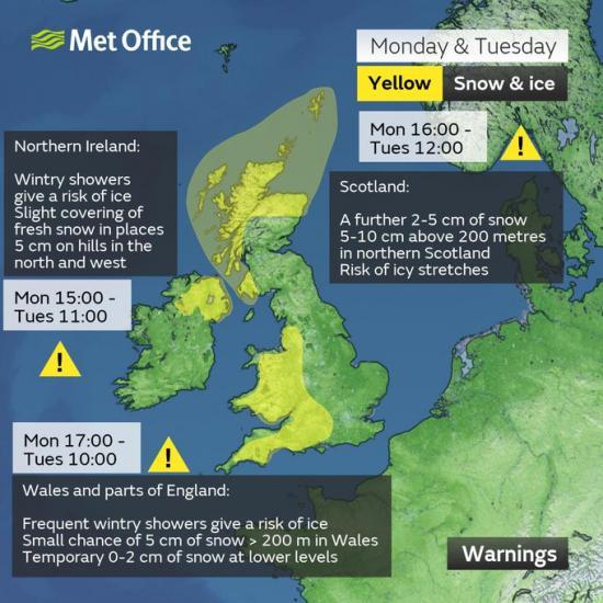
National Severe Weather Warnings for snow and ice are currently in place and are likely to be updated through the week.
Last night, the UK experienced its coldest night of winter so far, with -13.3°C recorded in Loch Glascarnoch in Scotland. Southeast England was much milder though, with temperatures remaining in double figures in places. That mild air has now been swept away by a cold northwesterly flow, which will allow further very low overnight temperatures to occur at times this week, especially where there is snow cover. But even away from snow cover, there will be widespread night frost and below average temperatures by day.
Met Office Chief Meteorologist, Frank Saunders, said: "Hail, sleet or snow showers are expected to affect parts of Scotland and Northern Ireland, spreading to Wales and parts of northwest England this evening, before moving into part of southwest England, the Midlands and southern England during the early hours of Tuesday. Rain or hail is more likely towards some western coasts.
"Icy stretches which develop overnight as a result of these showers, or the recent wet conditions, could bring some disruption to travel. In addition to the ice, we could see snow accumulations of a few cm above 200 metres, with a chance of greater than 5 cm above 200 metres in Wales. The heaviest snow showers may also produce temporary accumulations of 0-2 cm at low levels. It is not possible to say exactly where this snow might fall, so it's important that people are prepared."
Our Social Media