Meygen Tidal Project - Navigation & Fisheries
11th December 2011

Information from the Meygen materials supplied at the public meetings in December 2011. The full pubicatiosn are online at www.meygen.com.
Navigation
The 86 turbines are fully submerged and will have a minimum under-keel
clearance of 8m to Lowest Astronomical Tide (LAT).
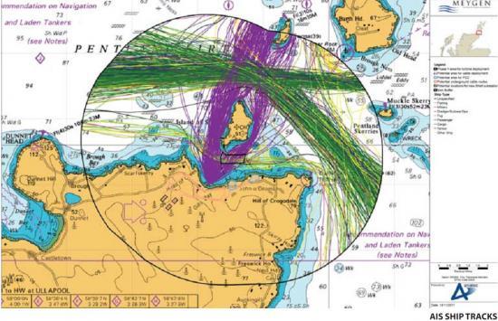
Data collected on users of the Inner Sound found 3 distinct groups:
1) The Pentland Ferry - operating a service from Gills Bay to St Margaret's
Hope, running north to south either side of the Stroma depending on
the local conditions
2) Transiting vessels - going east/west. These are generally i shing vessels
with draughts between 3 and 8m
3) Local creel boats working and transiting the area.
Navigation Risk Assessment
A Navigation Risk Assessment was carried out to quantify the risks associated
to vessels from the Project, now and on future predicted levels of traffic:
The key impacts identified were:
1) Drifting/Powered collision with installation vessel during construction phase
2) Displacement of vessels during construction phase (including safety zones for installation vessels)
3) Drifting/Powered collision risk with operating turbines
4) Increase in vessel-to-vessel collision risk due to re-routeing
Installation and maintenance vessels -
Work vessels and their associated safety could severely restrict the sea room available to vessels transiting east-west through the Inner Sound if a standard 500m zone is used. However, MeyGen seeks only to establish the minimum safety zone required to ensure the safety of working vessels and allow suitable sea room for transiting and working vessels. MeyGen will continue consultation with the MCA, DECC, the appointed contractor and local stakeholders on this matter.
Turbine Collision
For shallow-deep draught vessels, the risk of collision with turbines is assessed to be low. This assumes industry good practice will be applied to minimise this impact, including correct charting and publication of turbines and liaison with local stakeholders.
Fisheries
From the i shing vessel tracks recorded during the combined AIS survey period (16 weeks from 2010 to 11), 37 vessels used the Inner Sound and 96 used the Outer Sound. All were transiting as opposed to i shing. Coni rmed by analysis of VMS data and sightings data from over-l ights and Royal Navy patrols. All the sources agreed that vessels tended to transit the Inner Sound as opposed to i shing, and that the vast majority were UK-registered.
From the local consultation, three John O'Groats based skippers were identified to fish in the Inner Sound. The creel boats they use are less than 12m in length and have draughts up to about 1.5m. These local vessels use creels to catch lobsters, brown crabs and velvet crabs. They also fish areas to the west, around Stroma and further east. The centre of the Inner Sound where the Project area is located is mostly fished in spring/summer and mainly for lobster. However, fishing is limited as it requires a combination of neap tides and good weather, due to the time it takes to deploy and haul creels between tides.
Fisheries impacts
Throughout the Project life-cycle there is likely to be some exclusion to the local fishing fleet, including displacement from a small percentage of the local fishing grounds and access restrictions during installation and maintenance operations. However, such impacts will be of a temporary nature and will only affect a small number of fishing vessels.
For more about the project and MeyGen go to www.meygen.com
Related Businesses
Related Articles
