Caithness flood risk for properties after 2039 - Insurance Premiums May See Big Rises
18th May 2026
After 2039 Flood insurance will no longer be subsidised. Prices will reflect real flood risk.
For some households, especially in high‑risk coastal or river areas, this could mean substantial premium increases unless risk‑reduction measures are in place.
1. Physical flood risk in Caithness
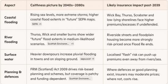
Coastal:
SEPA’s present‑day and future coastal maps show increased flood extents along exposed coasts under a high‑emissions climate scenario towards the end of the century.
That bites most around Wick, Thurso, Scrabster, low‑lying harbour areas, and any reclaimed or flat coastal land.
Rivers and burns:
Future river maps widen the medium‑likelihood floodplain for rivers such as the Thurso and Wick, and for some smaller watercourses.
Properties already near the mapped “medium” or “high” likelihood zones are the ones most exposed to future risk‑based pricing.
Surface water:
SEPA’s surface‑water and small‑watercourse maps—especially the “medium probability plus climate change” layers—show more ponding and overland flow in built‑up areas.
In Caithness that often means road dips, junctions, and older estates with poor drainage, not just obvious river or coastal spots.
2. What changes when Flood Re ends in 2039
After 2039, insurers stop using Flood Re and move fully to risk‑reflective pricing again. For Caithness that likely means:
Low‑risk majority:
Most inland Caithness properties, especially on higher ground or well away from mapped flood extents, should still be insurable at broadly “normal” prices—though climate‑change loading will creep in.
High‑risk pockets:
Houses in mapped coastal, river, or surface‑water risk zones can expect steeper premiums and/or excesses, because there’s no longer a pooled subsidy to smooth out that risk.
Some older riverside or harbour‑side properties could become marginal—insurable but only at a price that bites into fixed incomes.
Market behaviour:
Big insurers will lean heavily on SEPA/UKCP‑based models and their own catastrophe analytics; they’ll differentiate street‑by‑street, not just by postcode.
Any local flood‑protection scheme, bund, or upgraded drainage that is properly recognised in the data can materially soften pricing for that micro‑area.
3. Practical way to “score” a Caithness property now
For any given house (or cluster of streets), you can roughly grade post‑2039 insurance risk by:
Checking SEPA maps (present + future):
Look at river, coastal, and surface‑water layers, and then the future scenario for each.
If a property sits inside medium or high likelihood in the future maps, assume meaningful premium pressure after 2039.
Asking three blunt questions:
Is there a history of flooding or near‑misses? (Local memory often beats models.)
Are there formal defences or only sandbags and hope?
Has the building been made flood‑resilient? (Raised electrics, hard floors, flood doors, etc.)
Translating that into a risk band:
Green: Outside mapped risk now and in future; no known local issues → modest climate‑related increases only.
Amber: Brushed by future flood extents or known drainage issues → noticeable premium/excess increases, but still insurable.
Red: Clearly within future flood extents or repeatedly flooded → high premiums/excesses; affordability and mortgageability become live concerns post‑2039.
4. What Caithness can realistically do before 2039
At property level
Install resilience: flood doors, non‑return valves, raised services, water‑resistant finishes—especially for “amber” and “red” streets.
Document it: keep photos and invoices; insurers and lenders will increasingly want evidence, not anecdotes.
At community/council level
Lean on SEPA data in planning fights: use the future maps to challenge daft development on floodplains that would worsen everyone’s risk.
Push for targeted schemes: small‑scale bunds, improved culverts, and surface‑water management in Wick, Thurso and vulnerable villages can have outsized insurance benefits if they’re properly modelled and recorded.
What I Might Mean
A street‑level, Caithness‑specific look at how Wick and Thurso locations are likely to fall into green / amber / red insurance‑risk bands once Flood Re ends in 2039 and insurers revert to full risk‑reflective pricing.
This is not a prediction of premiums, but a risk‑classification framework based on SEPA present‑day and future flood‑likelihood mapping, local topography, and known drainage patterns.
Wick: Street‑by‑Street Likely Classification (Post‑2039)
RED — High future flood‑risk, likely steep premium/excess pressure
These are areas where SEPA’s future river/coastal/surface‑water maps show clear exposure, meaning insurers will price aggressively once subsidies end.
Lower Pulteneytown — especially Bank Row, Harbour Terrace, Miller Street, Williamson Street.
Low‑lying, close to Wick Harbour, exposed to coastal surge + surface water.
Future coastal‑flood extents expand inland under climate‑change scenarios.
Riverside areas near Wick River — Riverside Road, Lower Dunbar Street, Breadalbane Crescent.
Future river‑flood maps show wider inundation zones.
Historic near‑misses and drainage issues compound the risk.
South Quay / Harbourfront
Direct exposure to storm surge; insurers will treat this as high‑risk without Flood Re.
AMBER — Moderate risk; insurable but with noticeable post‑2039 increases
These areas sit near future flood extents or have surface‑water vulnerabilities, but are not the highest‑risk zones.
Argyle Square & surrounding streets
Slight elevation helps, but surface‑water pooling appears in SEPA maps.
Huddart Street / Henrietta Street area
Not river‑exposed, but pluvial flooding risk increases under future rainfall scenarios.
Northcote Street / Willowbank
Some surface‑water flow paths; insurers may load premiums but not severely.
GREEN — Low risk; normal market pricing likely
These areas sit well outside future flood extents and have favourable topography.
Hillhead
Elevated, minimal mapped risk.
Newton / Broadhaven
Coastal but higher ground; not in SEPA’s future inundation zones.
Pulteneytown upper streets
Higher elevation than the harbour‑side grid.
Thurso: Street‑by‑Street Likely Classification (Post‑2039)
RED — High future flood‑risk
These are the areas where Thurso River or coastal surge exposure is significant in future SEPA maps.
Riverside Road / Janet Street / Smith Terrace
Adjacent to Thurso River; future flood extents widen meaningfully.
Insurers will treat this as high‑risk once Flood Re ends.
Scrabster Low‑lying Harbour Area
Coastal surge exposure increases under climate‑change scenarios.
Sir George’s Street (lower section)
Close to river and low‑lying; surface‑water pathways also present.
AMBER — Moderate risk
Areas with surface‑water vulnerability or near‑river proximity but not in the highest‑risk zones.
Pennyland / Burnside
Some surface‑water flow paths; moderate risk.
Mount Pleasant area
Slightly elevated but still shows future surface‑water pooling in places.
Ormlie area
Mixed risk: some streets green, others amber due to drainage issues.
GREEN — Low risk
These areas are well outside future flood extents and sit on higher ground.
West Gills / Upper Thurso outskirts
Elevated, minimal mapped risk.
Upper Mount Vernon
Good elevation, no river or coastal exposure.
Thurso East (higher sections)
Coastal but elevated; not in future inundation zones.
What this means for Caithness homeowners after 2039
Green areas → normal pricing with climate‑change loading.
Amber areas → higher premiums/excesses but still competitive.
Red areas → steep increases; affordability becomes a real issue unless resilience measures or new defences are recognised by insurers.
When Flood Re ends in 2039, home insurance for flood‑risk properties will move to full risk‑based pricing, meaning premiums and excesses will reflect the true flood risk of each home. This could make insurance much more expensive for some households unless wider flood‑risk management improves.
What actually happens in 2039?
Flood Re is legally required to shut down in 2039, and the market will return to a free, fully risk‑reflective system for flood insurance.
That means:
Insurers will no longer be able to pass high‑risk homes into Flood Re for subsidised reinsurance.
Prices will be set entirely by insurers, based on the actual flood risk of each property.
Homes in high‑risk areas may face significant premium increases or very high excesses.
Some properties could become difficult or impossible to insure affordably unless risk is reduced.
Flood Re’s own Transition Plan makes this explicit: the goal is to prepare the market so that insurance remains available and affordable after 2039, but achieving this depends on factors outside Flood Re’s control, such as government investment, local flood defences, and climate change impacts.
What determines whether insurance stays affordable after 2039?
Flood Re identifies three critical areas (“buckets”) that must improve before 2039:
Reducing flood risk — better defences, drainage, natural flood management, and planning rules.
Reducing the cost of flood damage — through resilient repairs, raised electrics, flood doors, etc.
Ensuring an effective insurance market — competition, accurate risk modelling, and fair pricing.
If these areas don’t improve enough, the market will still revert to risk‑based pricing — meaning higher costs for homeowners.
What homeowners can do before 2039
Flood Re is already pushing “Build Back Better”, which funds up to £10,000 of flood‑resilient repairs after a claim. This is designed to reduce long‑term risk and keep future premiums down.
Homeowners can prepare by:
Installing property flood resilience (PFR) measures.
Checking SEPA flood maps for updated risk.
Ensuring any renovations include resilient materials.
Pressing councils and government for local flood‑defence investment.
Bottom line for homeowners After 2039:
Flood insurance will no longer be subsidised. Prices will reflect real flood risk.
For some households, especially in high‑risk coastal or river areas, this could mean substantial premium increases unless risk‑reduction measures are in place.