Pentland Firth Works Operations - Details For Mariners
11th March 2015
James Fisher Marine Services
Booths Park House
Chelford Road
Knutsford
Cheshire
Main Contact
Stan Groundwater
s.groundwater[AT]james-fisher.co.uk
tel 01856831380 mob 07747843712
All positions to be quoted in World Geodetic System 1984 [WGS84], lat. / long., in deg./ minutes. & 3 decimal places of minutes.
Works schedule and purpose
Date/s: 20th March 2015 until 31st July 2015
Operations will take place during the date range at approximately 4 week intervals
Inspection of horizontal drilling exit points along with minor remedial work at drill exit holes.
Diving operations will be undertaken during slack water periods, out with that time C-Salvor may deploy cameras suspended below the vessel.
Vessel/s onsite
MV C-Salvor
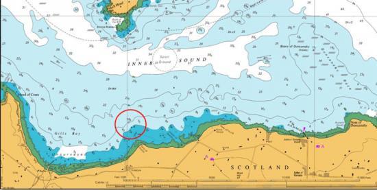
Maximum extent of projected works
058° 38' 47.80856" N
003° 07' 59.95327" W
Moorings will be located within 500m of the above coordinates
Buoys and markers to be displayed on site Mooring buoys will be deployed / recovered for the duration Colour - Yellow
Light
Flash Pattern
Yes
Area to be avoided
As stated above and indicated on chart at Fig1
Seabed post operations
On completion of works the specified coordinates will be clear from all hazards and obstructions.
Instructions to vessels
Vessels involved will be keeping continuous listening watch on Channel 16 and will display appropriate lights and marks as required by the International Rules for Preventing Collisions at Sea.
Mariners are requested to give the works a wide berth